Map Reading

Click on the graphics for larger version (this is a picture intensive page - please be patient loading.)

For a printer friendly version, click here.

A map is a graphic representation of a portion of the earth's surface as seen from above, drawn to scale.  A map provides information on the existence; location; and distance between ground features such as towns and roads. While there are literally thousands of different types of maps, they basically fall into one of these categories:
bulletTopographic maps: This is your typical USGS (United States Geological Survey) map.  It portrays variations in terrain; heights of natural features; and extent of vegetation cover.  Relief is represented by contour lines.
bulletTerrain models: This is a scale model of natural and man-made terrain features.  It provides a means to visualize the terrain depicted on a map in three dimensions.
bulletPhoto and Photomosaic maps: This is a reproduction of an aerial photograph or a series of photographs, upon which grid lines; marginal data; place names; route numbers; important elevations; boundaries; and scale and direction have been added.

Topographic maps not only depict a portion of the earth's surface to scale, but also incorporate other information to assist the map user.  The following list details information that is currently standard to all USGS topographic maps.

bulletMap Producer Identification: The agency which produced the map is identified in the top left-hand corner of the map sheet.
bulletMap Sheet Name: The sheet name is found in two places; the top right-hand corner and the lower right-hand corner of the map sheet.  A map sheet is named after the most prominent man-made or natural physical feature depicted on that sheet.  Also found here is the area of the earth's surface portrayed on the map.  For example, if a map sheet is a 7.5 minute series or quadrangle, then it covers 7.5 minutes of latitude and longitude.  This can also be determined by observing the latitude and longitude coordinates of the four corners of the map.
bulletMap Specific Legend: This legend depicts features specific to this map sheet and is located in the lower right-hand corner.
bulletThe State Locator: Graphically depicts the location of the map in respect to a state's boundaries and can be found in the lower right-hand side of the map.
bulletScale: The scale of the map is found in the bottom center of a map sheet.  The scale gives the ratio of map distance to the corresponding distance on the earth's surface.
bulletGraphic Bar Scales: Found at the bottom center of the map sheet, these rulers are used to convert map distances to ground distances and to convert distances between different units of measure.
bulletContour Interval: Also found at the bottom center of the map sheet below the graphic bar scales.  These show the vertical distance between contour lines on the map and the unit of measure used.
bulletDeclination Diagram: Sometimes referred to as the G-M, (grid-magnetic angle) is found in the lower margin of the map sheet to the left of the graphic bar scales.  The declination diagram is the angular difference between true north and either magnetic or grid north, for the particular portion of the earth's surface depicted on the map. Declination diagrams are seldom plotted exactly to scale.  The relative position of the directions is obtained from the diagram, but the numerical value of the declination should never be measured from the angles.  Use the written value of the declination provided to the left and right of the diagram.
bulletDatum Information: Found below the contour interval note and contains information that can be used with a GPS unit.
bulletMap Information Note: Contains information about the production of the map and can be found in the lower left-hand corner of the map sheet.
bulletIndex To Adjoining Sheets Diagram: Found in the lower right-hand portion of the map sheet and depicts the location of the map sheet you are using in respect to adjoining sheets.

Locations of features depicted on a topographic map can be determined by using latitude and longitude (also known as the geographic coordinate system); township and range land survey system; or the military grid reference system (MGRS).

bulletLatitude & Longitude: The fundamental way of expressing the location of any spot on earth is with a global reference system that is accepted by all people.  This accepted reference system is a coordinated grid system that uses imaginary east-west and north-south lines that encircle the earth.  The east-west lines are called lines of latitude.  Lines of latitude are parallel to each other (and hence are also called parallels) and to the equator, which is a special parallel that circles the earth exactly midway between the north pole and the south pole.  The location of a given parallel is designated as the angular distance between the parallel and the equator as measured from the center of the earth.  This angular distance ranges from zero degrees at the equator to ninety degrees at either pole.  Therefore, latitude indicates how far a place is located to the north or south of the equator.  Lines of longitude (or meridians) run north and south perpendicular to the equator (and all other parallels) and meet at both poles.  The location of a given meridian is designated as the angular distance between the meridian and the prime meridian, which is a line of longitude running through Greenwich, England.  This angular distance ranges from zero degrees at the prime meridian to 180 degrees on the opposite side of the globe.  Therefore, longitude indicates how far a place is located to the east or west of the prime meridian.  Together, parallels and meridians comprise a coordinated grid system, called the graticule, which makes it possible to locate any spot on the globe.  In locating a particular place on earth, the latitude is always stated first, in degrees, minutes, and seconds (depending on the accuracy required) and followed by a designation of N (for north) or S (for south) relative to the equator.  Next, the longitude is given in degrees, minutes, and seconds, followed by E (for east) or W (for west) relative to the prime meridian.

Latitude & Longitude

bulletTownship and Range Survey System: The federal government land office survey system was established in 1812 to facilitate the surveying and selling of land in the newly acquired lands west of Ohio.  It is a system unique to the mid-western and western portions of the United States.  As the area became consolidated into territories and eventually into states, the land there was divided into 6 mile square units of land.  Each 6 square mile unit was numbered corresponding to its position relative to a parallel of latitude that served as the base line of the survey, as well as a selected meridian of longitude called a principal meridian (not to be confused with the Prime Meridian.)  Thus each 6 mile square piece of land was designated as either north or south and east or west.  The north or south designation is referred to as township and the east or west designation is referred to as range.  The entire 6 mile square piece of land however, was referred to as a township.  Each 6 mile square piece of land was further subdivided into 36 1-mile by 1-mile units called sections.  Each of the 36 sections are designated numerically beginning in the northeast corner of the township.  Each section can be subdivided still further into halves and quarters.
bulletThe Military Grid Reference System (MGRS): As the lines of latitude and longitude are curved (as is the earth), they are not depicted well on flat surfaces (such as a maps.)  The sections of the earth enclosed by intersecting latitude and longitude lines are not all of the same size and shape.  This is particularly true in the extreme northern and southern areas of the earth.  These problems complicate the location of points and measurements of directions.  To overcome these problems a rectangular grid is made out of the earth's surface, between 84 degrees north latitude and 80 degrees south latitude. It divides the earth's surface into 60 grid zones.  Each zone is 6 degrees in longitude and numbered from 1 to 60, west to east, beginning at 180 degrees longitude (the international date line.)  This system then divides the earth's surface into 20 zones by latitude, each of which is 8 degrees in latitude and lettered from C to X (the letters I & O are omitted) beginning at 80 degrees south latitude.  Note: row X is 12 degrees in latitude.  Thus, this portion of the earth's surface has been divided into 1,200 areas each of which can be identified through an alpha-numeric label called a grid zone designation. An area's grid zone designation is determined by reading right and then up.  MGRS enables greater accuracy in expressing locations by breaking the flattened (and hence inaccurate) globe into small units of measure.

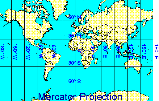
Mercator Map

The shortest distance between two points is a straight line, but on the surface of a globe the shortest distance is an arc known as a great circle.  If you were to plot the route of a great circle on most maps, it would not appear to be a direct route.  This is due to the distortion caused by projecting the curved surface of the globe onto a flat surface.  Perhaps the most widely used map is the Mercator Cylindrical Projection.  The Mercator map is very useful for navigation because a straight line on the map corresponds to a compass heading.  If you look carefully at the map below, both parallels and meridians are straight lines and cross at right angles.  The meridians are equally spaced, but parallels are not.  This is because the Mercator projection is constructed by straightening the lines of longitude and by increasing the space between latitude equal to the space of longitudinal widening.  This projection is most accurate within 15 degrees of the equator.  Distortion is so severe near the pole that the northern and southern limits of the map are fixed at the 84th parallel.  The Mercator projection has given many people a distorted perception of the size of the continents.  Greenland, for example, appears larger than South America when actually Greenland is only one eighth of the size of South America.

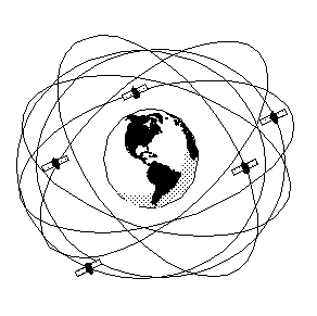
Because lines of longitude merge at the poles, the distance represented by one degree of longitude is greatest at the equator and decreases as latitude increases. For example, at the equator a degree of longitude is about 111 kilometers (or 69 miles), while at 60 degrees latitude, a degree of longitude is only about 56 kilometers (or 35 miles.)  At the poles, the meridians intersect, so a degree of longitude is zero kilometers (that's because there are no degrees of longitude at the poles.)  Nevertheless, we can easily determine the distance between two places on the globe even if their latitude is not the same.

Global Positioning Systems (GPS)

GPS was developed by the U.S. Department of Defense as a system that would provide global, all-weather, 24 hour positioning capability.  GPS is now also used in civil applications mostly for navigation and mapping.

Presently, 24 GPS satellites orbit the earth at a distance of about 20,000 km.  Four satellites are in each of six different orbital planes.  This arrangement insures that at least four and as many as eight satellites are visible above the horizon from any spot on Earth.

GPS satellites orbiting the Earth

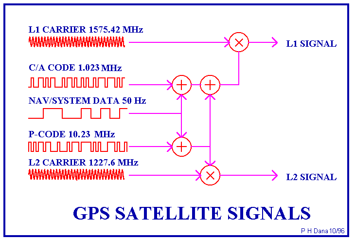
Onboard each satellite are atomic clocks that keep precise time.  Each satellite broadcasts its location and time information as a code on two microwave carrier signals (L1 frequency of 1575.42 MHz and L2 frequency of 1227.60 MHz).

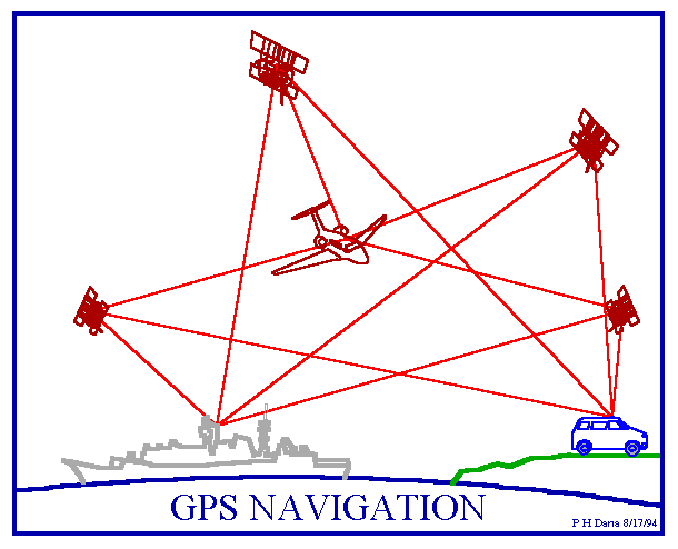
The basis of GPS positioning is that your location can be determined if you know the distance to four (4) different satellites.  This technique is called triangulating or ranging.  The GPS receiver measures the distance to the satellites using the travel time of a coded radio signal and the speed of light.  Because your handheld GPS unit does not contain an atomic clock to precisely measure time differences, it contains a directory (called an almanac) of the projected position of each of the satellites in the orbital planes.  The GPS receiver uses this information to calculate the time differences and thus the distance to each satellite.

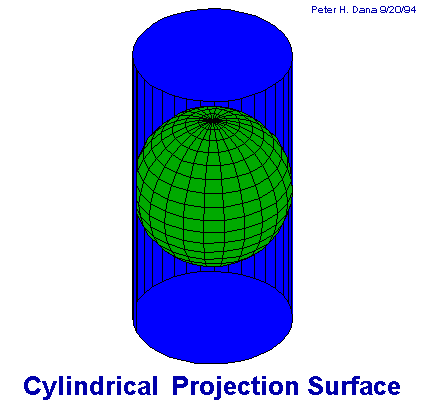
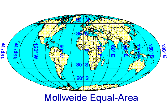
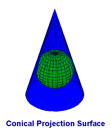
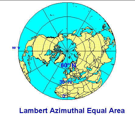
In order for GPS to work, the antenna at the end of the GPS unit needs to receive the signals from the orbiting satellites.  Therefore, you need to be outside with a view of the sky.  Mountains, trees, buildings and other obstacles can block the satellite signals or cause the signals to bounce around creating positioning inaccuracies.  When you turn on the GPS unit, it will take some time for enough information from the satellite to be processed before your position is "fixed" or known.  The military uses an encrypted code on the L2 frequency to obtain ±5m accuracy on handheld GPS receivers.  The signal code carried by the L1 frequency used by civil GPS units is randomly degraded and scrabbled (called selective availability, or SA.)  Therefore, a position determined by the handheld civil GPS units is approximately ±100 m.

Map Projections & Types

A map projection is the systematic arrangement of a planet's parallels and meridians onto a plane surface.  These meridians and parallels become the projection graticule.  The graticule takes on different forms depending on the type of projection plane surface; the point or line of tangency; the aspect; and direction of an imaginary projection light source.  The projection process also involves the transformation of land features such as coastlines and land boundaries.

All map projections have some type of distortion or deformation.  Depending on the projection properties, the distortion may be of area; shape; size; distance; direction; or scale.  No projection is free from all distortions, but each contains only some distortion.  The cartographer or mapmaker must select a projection which will result in a minimum of distortion in relation to the map theme or purpose;  the amount of land area shown; and the portion of the planet's surface being represented on the map.  As previously noted, all map projections contain some types of distortion.  Some projections preserve shape and direction while distorting area.  Others maintain area but distort shape and scale.  In many projections scale may vary from place to place and in all projections distortion will increase away from the places of tangency.  The types of distortions are a function of the way the projection is constructed.  As most projections have been derived mathematically, the type of distortion is often a function of certain mathematical relationships specific to a given projection.

Map projections are grouped into three families: Cylindrical, Conic and Azimuthal, with Pseudocylindrical projections forming a variation on the Cylindrical Family.  These families are based on the configuration of the plane onto which the globe (sphere) is projected.

In addition to map projections, there are an endless variety of types of maps.  Below are just a few of the types available.

Cylindrical Map Pseudocylindrical Map Cone Map

Azimuthal Map Aerial Map Sterographic Map

The modern system of map symbols owes much to the reign of Napoleon Bonaparte.  During the first part of the 19th century France became the leader in cartography with the introduction of such cartographic innovations as a comprehensive system of incorporating symbols onto topographic maps.

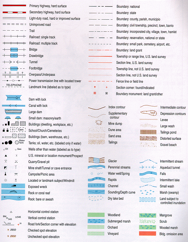
Table of Map Symbols

(Be sure to expand picture in order to read fine details)

On a standard topographic map, the colors used and the features they represent are:

Black: Indicates man-made features, such as buildings.

Gray: Indicates built-up areas; relief features; and elevation.  This color enables the map to be red-light readable.

Red: Depicts major roads and highways.

Brown: Depicts contour lines.

Green: Identifies vegetation such as woods; orchards; and vineyards.

Blue: Identifies water features such as lakes; swamps; rivers; and streams.  Intermittent water features are depicted with a dashed line.

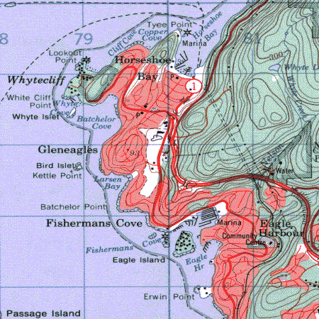
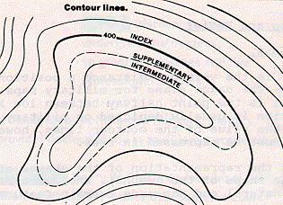
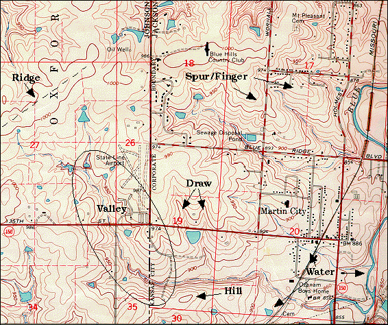
Topographic Map

The main advantage of a topographic map is that it portrays the elevations and relief of the portion of the earth's surface it depicts.

The representation of the shapes of natural terrain features (the shape of the ground) is called the relief.

Contour lines are the most common method used to depict relief; elevation; and depression on a topographic map.  A contour line is an imaginary line on the ground above or below a datum plane (sea level - which is measured as either "0 Feet" or "O Meters" depending on map scale).  There are three (3) types of contour lines:

bulletIndex: starting at mean sea level (zero), every fifth contour line is a heavier line with the elevation for that line printed on it.  For most maps the contour interval is 10 feet, thus the index contour lines are every 50 feet.
bulletIntermediate: these are lighter contour lines that fall in between the index contour lines and do not have the elevation printed on them.
bulletSupplementary: these are dashed lines used to show sudden changes in elevation of at least half the value of the contour interval.

In addition to contour lines, bench marks are surveyed elevations at specific points and are usually indicated by the letter "X."  Finally, spot elevations are points that may be surveyed and are used to depict elevations at prominent terrain features, such as hill tops and road intersections.

Although the use of contour lines provides a more scientific and accurate portrayal of elevations, the relief that is depicted by contour lines can be difficult to visualize in 3-D.  The following methods are used in depicting certain terrain features:

bulletHills: depicted by closed rings of contour lines that get successively smaller towards the top of the hill.

bulletValley: a stretched out groove in the land usually formed by streams or rivers.  A valley begins with high ground on three sides and usually has level ground of a lower elevation at its bottom where the water course is found.  Contour lines forming a valley are either 'U' or 'V' shaped with the closed end of the V pointing upstream towards higher ground.

bullet

Ridge: a sloping line of high ground.  The contour lines forming a ridge tend to have a 'U' or 'V' shape with the closed end pointing away from the high ground.

bulletDepression: a low point in the ground or a sinkhole surrounded by higher ground on all sides.  It is depicted by closed contour lines with hachures pointing inward toward the lower ground.

bullet

Draw: a less developed stream course than a valley.  It has high ground on three sides with no level ground in the draw.  It is depicted by 'U' or 'V' shaped contour lines, with the closed end of those lines pointing towards the top of the draw (higher ground).

bulletSpur/Finger: a sloping line of higher ground with lower ground on three sides. It is depicted by 'U' or 'V' shaped contour lines with the closed end of these lines pointing towards the bottom of the finger (lower ground).

bullet

Cliff: a vertical or near vertical abrupt change in the land.  It is depicted by very closely spaced contour lines or by converging contour lines into one contour line that is some times marked with hachures that point toward the lower ground.

bulletMan-made terrain features: a man-made terrain feature created by digging through high ground, usually for transportation routes, is called a cut.  It is depicted by a contour line drawn along the cut line with hachures pointing toward the lower ground.  Another man-made feature is a fill which results from the filling of a low area, usually to accommodate transportation routes. It is depicted by a contour line drawn along the fill line with hachures on the contour line pointing toward lower ground.

Summary Contour Map labeling all the above terrain features.

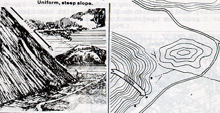
As we have stated, relief is basically the shape of the land.  As such, the spacing of the contour lines also tells much about the relief.  For example, you already understand how contour lines can represent a hill, but how steep is the hill and what type of slopes can be found on the sides of the hill?

Uniform Gentle Slope

This type of slope is depicted by contour lines that are evenly spaced and wide apart.

Uniform Steep Slope

This type of slope is depicted by contour lines that are evenly spaced and close together.

Concave Slope

This type of slope is depicted by contour lines that are close together towards the top of the terrain feature and are widely spaced towards the bottom of the slope.

Convex Slope

This type of slope is depicted by contour lines that are widely spaced towards the top of the terrain feature and are close together towards the bottom of the slope.


horizontal rule

Compass  >        <  Compass Lab  >        <  Introduction To Science  >

Topographic Map Lab  >        <  Website Directory  >