|
Walking with the Dinosaurs Lab - Part 2 Note: Remember you are responsible for graphs, charts and other items that form part of the overall summary of this topic. Upon completion, the Walking with the Dinosaurs Lab activity will introduce you to the life of a paleontologist from the planning of an expedition, to the actual “dig” of a dinosaur skeleton and finally to the building of a dinosaur showcase. Be sure to familiarize yourself with the Paleontological Studies notes; geologic timeline and extinction theory notes as you complete this lab. You may also wish to visit the Walking With Dinosaurs website. Be sure when completing the lab report, that you follow the given format. Vocabulary
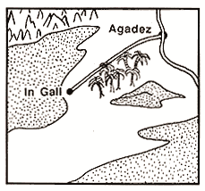
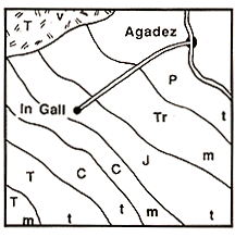
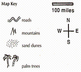
Background Luck plays a part in finding fossils, but research and hard work play a larger role. Your expedition team will need to use geographic maps, geologic maps and scientific reports to decide where to look for dinosaur fossils. Remember that a geographic map shows cities; villages; roads; trails and surface features (dry river beds; sandy areas; cliffs; mountains), as well as areas of exposed rock not covered by dirt, sand or grass, which might yield fossils. Your team will use this kind of map to plan campsites and vehicle routes. On the other hand, a geologic map shows the ages and kinds of rock that form on the surface of the land. Your team will use a geologic map to find rocks that formed during the dinosaur era. Geologists have mapped each distinct rock layer and have given each layer a different color and letter symbol. For example, Cretaceous rocks (145 to 65 million years old) are shown on geologic maps as different shades of green and labeled with the letter “K.” The key on geologic maps gives more information about the type of rock that composes each area. Some rock types include marine (ocean floor), terrestrial (land) and volcanic (volcanoes). Your team is interested in terrestrial rocks because that is where the fossil bones of the animals that lived on land will be found. To look for Cretaceous dinosaurs, your team will locate Cretaceous (green) areas in the maps and then check the key to make sure the rocks in these areas are terrestrial. Finally, scientific reports describe scientific discoveries. Before your team departed, they went to a library and found all the reports that described the area under investigation: its geology and its fossils. Your team then decided where to look by combing information from geographic maps, geologic maps, and scientific reports. Laboratory Activity – Hunting for Dinosaurs Remember that paleontologists use three sources of information to decide where to search:
The geologic map tells the age of the rocks (mammal era, dinosaur era, or older.) These rocks are divided into five (5) time periods:
Dinosaurs are found only in the rocks of Mesozoic age (dinosaur era.) A geologic map also indicates where the rocks were formed (on land, in the sea, or in a volcano). Dinosaurs are usually found in terrestrial rocks. Dinosaurs or other land animals are never found in volcanic rocks and rarely found in marine rocks. Directions Your team of paleontologists wants to discover new Cretaceous dinosaurs in the Sahara Desert in Africa. First, you go to the library to look for previous scientific reports on the area. You find one report with pictures of large pieces of fossil bones that look like they might belong to a dinosaur. The report also mentions that there is a large area of exposed rock where the fossil fragments were found. This sounds interesting, but there is no map that shows exactly where the fossil fragments were found. All you know is that the fossils were found somewhere near an oasis called In Gall. Your team returns to the library to study maps of the area. You find a geographic map and a geologic map of the area. Now you have the information you need to lead an expedition to the area and decide the best place to look for fossils.
Questions
|


